

The Story of Weather in the Mountains of Adventure
In every season of the year, the weather here is cooler and more dynamic than in any of the major cities of the Southeast. What’s up with that?
Our family has had homes in the Mountains of Adventure for twenty-five years. At first we were here part-time, with day jobs 100 miles northwest in Nashville, but for the past ten years, we’ve been here full-time, and for good reason: The Weather.
In every season of the year, the weather here is cooler and more dynamic than in any of the major cities of the Southeast. What’s up with that?
FIRST: IT COMES FROM THE GEOLOGY
Let’s start with a bit of a geology lesson: The Mountains of Adventure are actually a geological feature known as the Cumberland Plateau. This plateau runs, in some form, all the way from western New York to northern Alabama. It’s a left-over remnant from the once-much-larger Appalachian Mountain chain.
As the Appalachians (which were originally as tall as — and are much much older than the Rockies) wore down from weathering and erosion, much of the material ran off on the western side of the mountain range, creating a broad, flat plain that we now know as the Cumberland Plateau.
Most of that material was compressed and became a thick layer of limestone, but the upper 100 or so feet contained quartz, a different kind of dissolved rock, which was formed deep inside the massive, original Appalachians. This quartz contributed to what became a thick sandstone “cap” that protected the softer limestone below from further erosion. However, rain, snow and other weathering continued their relentless assault on the Plateau, and wherever cracks in the sandstone cap appeared, water worked its way down into the underlying limestone, dissolving it rather easily.
This process began, almost literally, to pull the rug out from under the sandstone cap. Over time, the sandstone collapsed into the voids beneath it, and valleys began to appear in what had been a nearly flat surface.
What you see today is a continuation of that process — waterfalls spilling over the edge of the remaining sandstone cap, continuing the work of slowly enlarging the valleys. Were it not for the sandstone cap, the Plateau would likely be completely eroded away by now. Over millions of years, relatively high amounts of annual rainfall (which we’ll get to in a moment) also enabled the entire Plateau — top, slopes and valleys — to become covered with forests, creating the amazing landscape we enjoy today.
SECOND: IT’S THE TOPOGRAPHY
Topography, from the latin words for ‘place’ and ‘writing’, describes a mapping technique that shows the elevation of a piece of land relative to the land around it. On a topographic map, the lines indicate land of equal elevation.
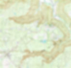
If you’ve never seen a topographic map of the southern Cumberland Plateau, take a look at the sample below that shows the Savage Gulf State Park area. You can clearly make out the valleys, amidst the relatively flat top of the Plateau. There are many places where the elevation difference, from Plateau top to valley floor, is over 1,000 feet! (Fun fact: The highest point in this area is Ross Mountain, in eastern Grundy County, at 2,300 feet above sea level.)
The ‘top’ of the Plateau is typically between 1,800 and 2,000 feet above sea level. The local towns of Monteagle and Sewanee are about 1,925 feet above sea level, considerably higher than the elevations of Chattanooga, Nashville and Huntsville (all between 600 and 700 feet), or Atlanta, at 900 feet.
Not only do these elevation differences make for some challenging (but rewarding!) hiking, but they actually also control the weather around here, in several different ways.
THIRD: IT’S THE ATMOSPHERE
Finally, Let’s talk rain, fog and snow: These forms of weather occur differently here, also due to the elevation. Meteorologists (weather forecasters) know that, in clear weather, for every 1,000 feet in elevation, the average air temperature drops by 5.4 degrees. (If it’s raining or snowing, that difference narrows to about 3.5 degrees).
So, do the math: You’re in Nashville in January, at 600 feet in elevation, looking out your window at a cold, 34 degree rainy day. You decide to decide to get in your car and head up to Monteagle, elevation 1900 feet. Chances are — assuming weather patterns are generally the same in both places — it will be 29 degrees and likely to be snowing when you arrive!
Same rules apply in Spring, Summer and Fall — except the temperatures are warmer. Summertime, on a sunny day: In Nashville, it’s 90 degrees. In Sewanee, 84 degrees. While they may not have fully understood the math back in the day, Southerners, pre-air conditioning, definitely knew that it was cooler up “on the Mountain”, and so they flocked here, starting in the mid-1800s, both to escape mosquito-borne diseases, like yellow fever, common in many coastal southern cities, and to beat the heat.
In those days, after coal mining and timbering, perhaps the single biggest driver in the Plateau’s economy was weather-induced tourism. Today, tourism is the number one economic driver of our region, thanks to our rugged wilderness, as showcased in our three State Parks, and at the University of the South, plus attractions like The Caverns and Baggenstoss Farms, and — of course — the “weather math”.
One other weather phenomenon of note: In any season, when it’s precipitating (meaning, something is falling out of the sky — rain, sleet or snow), chances are, we get more of it in the Mountains of Adventure. That’s generally due to a process called orographic lift, which is a fancy way of saying, “when moving air bumps up against the steep hillsides of the Cumberland Plateau, it must rise”. And often, when air rises, that squeezes more of the moisture out of the air.
On a sunny summer day, that creates a pleasant breeze up here. But if it’s precipitating, that means more of “whatever” will land on top of the Plateau: More snow, more rain, more sleet. Bottom line: Weather is just more efficient at doing its thing when air is forced to climb our mountainsides.
And, after the precipitating stops, there’s often fog, and lots of it, especially when it gets trapped in our valleys. (Check out two cool time lapse videos of the fog evaporating below!)
In fact, legend has it that the University of the South football team (based in Sewanee) was almost nicknamed the “Sewanee Fog” instead of the “Sewanee Tigers”. (In your author’s humble opinion, that would have been the ultimate “cool team name”, though I’m not sure what team mascot would’ve accompanied that label!)
- - - - - - - - -
And so — like our family did for many years, from the time our kids could walk ’til they left for college — you, too, can head for the Mountains of Adventure in any season, with confidence that whatever weather you left behind, it will be different (frequently more interesting, and definitely more fun!) up here “on the Mountain”!